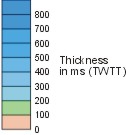
These are based on a combination of high-resolution shallow-seismic reflection data and available commercial deep-seismic reflection profiles. The maps show the general distribution and thickness, in milliseconds TWTT (two-way travel time), of the Neogene megasequences identified in each work package area. Colour boundaries without lines indicate minimum extent of the megasequence, corresponding to the limit of the seismic grid. The location of key wells and boreholes is indicated.
KEY TO MAP
Bathymetric contours in metres
RB
Rosemary Bank Seamount
AD
Anton Dohrn Seamount
HT
Hebrides Terrace Seamount
SSF
Sula Sgeir Fan
BF
Barra Fan
DF
Donegal Fan
ERW
East Rockall Wedge
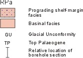
Area of prolonged sea-floor erosion. RPa is commonly a gravel-lag veneer.
GENERAL NOTE ON SEISMIC VELOCITIES COMMONLY USED IN DEPTH CONVERSION OF THE NEOGENE SUCCESSION
For the Neogene succession offshore NW Europe, the calibration of borehole and well data with seismic profiles is based upon the correlation of shallow boreholes with high-resolution seismic profiles. Experience has shown that meaningful time/depth conversions are commonly best achieved using acoustic velocities ranging from 1.5–1.65km/s TWTT for soft, unconsolidated Pleistocene–Holocene muds, to 1.8–2.0km/s TWTT for overconsolidated and lithified strata including Pleistocene glacial tills and shelf diamictons and older Neogene clastics. In the major depocentres that are the prograding wedges, a seismic velocity of 2km/s TWTT provides a reliable single average velocity for time/depth conversion of the total Neogene succession in this setting.
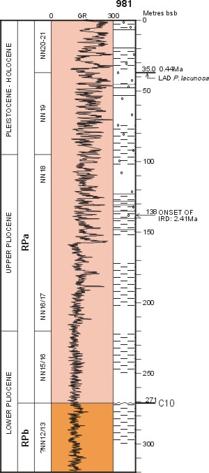
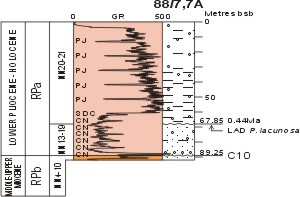
These illustrate the principal variations in lithology and wireline-log — gamma ray (GR) — signature for each megasequence. As BGS boreholes were logged through the drill-string, features such as pipe joints and collar necks are noted as they tend to modify the log signature due to variations in the thickness of the drillpipes. All depths are quoted in metres below sea bed (bsb), including the megasequence boundaries. For dating and correlation purposes the calcareous nannoplankton biozones are shown: the prefix 'NN' applies to the Neogene (Miocene–Holocene) zones, and 'NP' for the Palaeogene zones. Additional biostratigraphic and sedimentological information annotates the sections where appropriate.
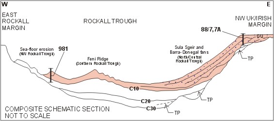
These composite schematic sections show the general setting of the Neogene megasequences on the Atlantic margin of NW Europe, and the relative locations of the key well and borehole reference sections. These sections are intended to provide a geological context for the reference sections, and as such they do not represent a single line of section across the margin that is being depicted.